- Arctic Ocean
-
an ocean N of North America, Asia, and the Arctic Circle. ab. 5,540,000 sq. mi. (14,350,000 sq. km).
* * *
Arctic Ocean
Introduction Arctic Ocean -
Background: The Arctic Ocean is the smallest of the world's five oceans (after the Pacific Ocean, Atlantic Ocean, Indian Ocean, and the recently delimited Southern Ocean). The Northwest Passage (US and Canada) and Northern Sea Route (Norway and Russia) are two important seasonal waterways. A sparse network of air, ocean, river, and land routes circumscribes the Arctic Ocean. Geography Arctic Ocean
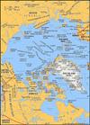
Location: body of water between Europe, Asia, and North America, mostly north of the Arctic Circle
Geographic coordinates: 90 00 N, 0 00 E
Map references: Arctic Region
Area: total: 14.056 million sq km note: includes Baffin Bay, Barents Sea, Beaufort Sea, Chukchi Sea, East Siberian Sea, Greenland Sea, Hudson Bay, Hudson Strait, Kara Sea, Laptev Sea, Northwest Passage, and other tributary water bodies
Area - comparative: slightly less than 1.5 times the size of the US
Coastline: 45,389 km
Climate: polar climate characterized by persistent cold and relatively narrow annual temperature ranges; winters characterized by continuous darkness, cold and stable weather conditions, and clear skies; summers characterized by continuous daylight, damp and foggy weather, and weak cyclones with rain or snow
Terrain: central surface covered by a perennial drifting polar icepack that averages about 3 meters in thickness, although pressure ridges may be three times that size; clockwise drift pattern in the Beaufort Gyral Stream, but nearly straight-line movement from the New Siberian Islands (Russia) to Denmark Strait (between Greenland and Iceland); the icepack is surrounded by open seas during the summer, but more than doubles in size during the winter and extends to the encircling landmasses; the ocean floor is about 50% continental shelf (highest percentage of any ocean) with the remainder a central basin interrupted by three submarine ridges (Alpha Cordillera, Nansen Cordillera, and Lomonosov Ridge)
Elevation extremes: lowest point: Fram Basin -4,665 m highest point: sea level 0 m
Natural resources: sand and gravel aggregates, placer deposits, polymetallic nodules, oil and gas fields, fish, marine mammals (seals and whales)
Natural hazards: ice islands occasionally break away from northern Ellesmere Island; icebergs calved from glaciers in western Greenland and extreme northeastern Canada; permafrost in islands; virtually ice locked from October to June; ships subject to superstructure icing from October to May Environment - current issues: endangered marine species include walruses and whales; fragile ecosystem slow to change and slow to recover from disruptions or damage; thinning polar icepack
Geography - note: major chokepoint is the southern Chukchi Sea (northern access to the Pacific Ocean via the Bering Strait); strategic location between North America and Russia; shortest marine link between the extremes of eastern and western Russia; floating research stations operated by the US and Russia; maximum snow cover in March or April about 20 to 50 centimeters over the frozen ocean; snow cover lasts about 10 months Economy Arctic Ocean
Economy - overview: Economic activity is limited to the exploitation of natural resources, including petroleum, natural gas, fish, and seals. Transportation Arctic Ocean -
Ports and harbors: Churchill (Canada), Murmansk (Russia), Prudhoe Bay (US)
Transportation - note: sparse network of air, ocean, river, and land routes; the Northwest Passage (North America) and Northern Sea Route (Eurasia) are important seasonal waterways Transnational Issues Arctic Ocean - Disputes - international: some maritime disputes (see littoral states); Russia is the first state to submit data to the UN Commission on the Limits of the Continental Shelf to extend its continental shelf by claiming two undersea ridges in the Arctic Ocean* * *
 Smallest of the world's oceans, it is almost completely surrounded by the landmasses of Eurasia and North America, and it is distinguished by a cover of ice. Lands in it and adjacent to it include Point Barrow in Alaska, the Arctic Archipelago, Greenland, Svalbard, Franz Josef Land, and northern Siberia. The ocean covers about 5,440,000 sq mi (14,090,000 sq km) and reaches a maximum depth of about 18,000 ft (5,500 m). Various sections are known as the Barents, Beaufort, Chukchi, Greenland, and Kara seas. Areas within the Arctic Circle were first explored in the 9th–12th centuries by the Norse. In the 16th–17th centuries explorers searching for the Northwest Passage reached the area; Martin Frobisher discovered the southern part of Baffin Island (1576–78), and Henry Hudson navigated the eastern coast of Hudson Bay (1610–11). Later explorers included Roald Amundsen, Fridtjof Nansen, Robert E. Peary, and Richard E. Byrd. Development of the area's natural resources was spurred by the discovery of oil in Alaska in the 1960s. Virtually all of the Arctic has now been mapped.
* * *
Introductionsmallest of the world's oceans, centring approximately on the North Pole.The Arctic Ocean and its marginal seas (the Chukchi, East Siberian, Laptev, Kara, Barents, White, Greenland, and Beaufort; some oceanographers also include the Bering and Norwegian Seas) are the least-known basins and bodies of water in the world ocean owing to their remoteness, hostile weather, and perennial or seasonal ice cover. This is changing, however, because the Arctic may exhibit a strong response to global change and may be capable of initiating dramatic climatic changes through alterations induced in the oceanic thermohaline circulation by its cold, southward-moving currents or through its effects on the global albedo resulting from changes in its total ice cover.Although the Arctic Ocean is by far the smallest of the Earth's oceans, having only a little more than one-sixth the area of the next largest, the Indian Ocean, its area of 5,440,000 square miles (14,090,000 square km) is five times larger than that of the largest sea, the Mediterranean. The deepest sounding obtained in Arctic waters is 18,050 feet (5,502 metres), but the average depth is only 3,240 feet (987 metres).Distinguished by several unique features, including a cover of perennial ice and almost complete encirclement by the landmasses of North America, Eurasia, and Greenland, the north polar region has been a subject of speculation since the earliest concepts of a spherical Earth. From astronomical observations, the Greeks theorized that north of the Arctic Circle there must be a midnight sun at midsummer and continual darkness at midwinter. The enlightened view was that both the northern and southern polar regions were uninhabitable frozen wastes, whereas the more popular belief was that there was a halcyon land beyond the north wind where the sun always shone and people called Hyperboreans (Hyperborean) led a peaceful life. Such speculations provided incentives for adventurous men to risk the hazards of severe climate and fear of the unknown to further geographic knowledge and national and personal prosperity.This section describes the Arctic Ocean and its marginal seas, discusses the physical characteristics and origin of the ocean floor, and outlines what is known about its physical oceanography and sea-ice dynamics.OriginThe tectonic history of the Arctic Basin in the Cenozoic Era (66.4 million years ago to the present) is largely known from available geophysical data. It is clear from aeromagnetic and seismic data that the Eurasia Basin was formed by seafloor spreading (seafloor spreading hypothesis) along the axis of the Nansen-Gakkel Ridge. The focus of spreading began under the edge of the Asian continent, from which a narrow splinter of its northern continental margin was separated and translated northward to form the present Lomonosov Ridge. The origin of the Amerasia Basin is far less clear. Most researchers favour a hypothesis of opening by rotation of the Arctic-Alaska lithospheric plate away from the North American Plate during the Cretaceous Period (144 to 66.4 million years ago). Better understanding of the origin of the Arctic Ocean's basins and ridges is critical for reconstructing the paleoclimatic evolution of the ocean and for understanding its relevance to global environmental changes.The sediments of the Arctic Ocean floor record the natural of the physical environment, climate, and ecosystems on time scales determined by the ability to sample them through coring and at resolutions determined by the rates of deposition. Of the hundreds of sediment corings taken, only four penetrate deeply enough to predate the onset of cold climatic conditions. The oldest (approximately 80-million-year-old black muds and 67-million-year-old siliceous oozes) document that at least part of the Arctic Ocean was relatively warm and biologically productive prior to 40 million years ago. Unfortunately, none of the available seafloor cores have sampled sediments from the time interval between 35 to 3 million years ago. Thus there is no direct evidence of the onset of cooling that produced the present perennial ice cover. All the other cores collected contain younger sediments that were deposited in an ocean dominated by ice cover. They contain evidence of terrigenous (land-derived) sediments formed by bordering glaciers and transported by sea ice.Topography of the ocean floorFrom the late 19th century, when the Norwegian explorer Fridtjof Nansen first discovered an ocean in the central Arctic, until the middle of the 20th century, it was believed that the Arctic Ocean was a single large basin. Explorations after 1950 revealed the true complex nature of the ocean floor. Rather than being a single basin, the Arctic Ocean consists of two principal deep basins that are subdivided into four smaller basins by three transoceanic submarine ridges. The central of these ridges extends from the continental shelf off Ellesmere Island to the New Siberian Islands, a distance of 1,100 miles (1,770 km). This enormous submarine mountain range was discovered by Soviet scientists in 1948–49 and reported in 1954. It is named the Lomonosov Ridge after the scientist, poet, and grammarian Mikhail Vasilyevich Lomonosov.The Lomonosov Ridge has an average relief of about 10,000 feet and divides the Arctic Ocean into two physiographically complex basins. These are referred to as the Eurasia Basin on the European side of the ridge and the Amerasia Basin on the American side. The Lomonosov Ridge varies in width from 40 to 120 miles, and its crest ranges in depth between 3,100 and 5,400 feet.The Eurasia Basin is divided into two smaller basins by a trans-Arctic Ocean extension of the Mid-Atlantic Ridge. This Arctic segment of the global ridge system is called the Nansen Cordillera, which was named for Fridtjof Nansen after its discovery in the early 1960s. It is a locus of active ocean-floor spreading, with a well-developed rift valley and flanking rift mountains. The Fram Basin lies between the Nansen-Gakkel Ridge and the Lomonosov Ridge at a depth of 14,070 feet. The geographic north pole is located over the floor of the Fram Basin near its juncture with the Lomonosov Ridge. The smallest of the Arctic Ocean subbasins, called the Nansen Basin, lies between the Nansen-Gakkel Ridge and the Eurasian continental margin and has a floor depth of 13,800 feet.The Amerasia Basin is divided into two unequal basins by the Alpha Cordillera (Alpha Ridge), a broad, rugged submarine mountain chain that extends to within 4,600 feet of the ocean surface. The origin of this seismically inactive ridge, which was discovered in the late 1950s, is undetermined and holds the key to understanding the origin of the Amerasia Basin. The Makarov Basin lies between the Alpha Cordillera and the Lomonosov Ridge, and its floor is at a depth of 13,200 feet. The largest subbasin of the Arctic Ocean is the Canada Basin, which extends approximately 700 miles from the Beaufort Shelf to the Alpha Cordillera. The smooth basin floor slopes gently from east to west, where it is interrupted by regions of sea knolls. The average depth of the Canada Basin is 12,500 feet.The Arctic Ocean is unique in that nearly one-third of its total area is underlain by continental shelf, which is asymmetrically distributed around its circumference. North of Alaska and Greenland the shelf is 60 to 120 miles wide, which is the normal width of continental shelves. In contrast, the Siberian and Chukchi shelves off Eurasia range from 300 to 1,100 miles in width. The edge of the continental margin is dissected by numerous submarine valleys. The largest of these, the Svyataya Anna Trough, is 110 miles wide and 300 miles long.Several factors in the Arctic Ocean make its physical, chemical, and biological processes significantly different from those in the adjoining North Atlantic and Pacific Oceans. Most notable is the covering ice pack, which reduces the exchange of energy between ocean and atmosphere by about 100 times. In addition, sea ice greatly reduces the penetration of sunlight needed for the photosynthetic processes of marine life and impedes the mixing effect of the winds. A further significant distinguishing feature is the high ratio of freely connected shallow seas to deep basins. Whereas the continental shelf on the North American side of the Arctic Ocean is of a normal width (approximately 40 miles), the Eurasian sector is hundreds of miles broad, with peninsulas and islands dividing it into five main marginal seas: the Chukchi (Chukchi Sea), East Siberian (East Siberian Sea), Laptev (Laptev Sea), Kara (Kara Sea), and Barents (Barents Sea). These marginal seas occupy 36 percent of the area of the Arctic Ocean, yet they contain only 2 percent of its water volume. With the exception of the Mackenzie River of Canada and the Colville River of Alaska, all major rivers discharge into these marginal shallow seas. The combination of large marginal seas, with a high ratio of exposed surface to total volume, plus large summer inputs of fresh water, greatly influences surface-water conditions in the Arctic Ocean.As an approximation, the Arctic Ocean may be regarded as an estuary of the Atlantic Ocean. The major circulation into and from the Arctic Basin is through a single deep channel, the Fram Strait, which lies between the island of Spitsbergen and Greenland. A substantially smaller quantity (approximately one-quarter of the volume) of water is transported southward through the Barents and Kara seas and the Canadian Archipelago. The combined outflow to the Atlantic appears to be of major significance to the large-scale thermohaline circulation and mean temperature of the world ocean with a potentially profound impact on global climate variability (see the figure—> ). Warm waters entering the Greenland/Iceland/Norwegian (GIN) Sea plunge downward when they meet the colder waters from more northerly produced freshwater, southward-drifting ice, and a colder atmosphere. This produces North Atlantic Deep Water (NADW), which circulates in the world ocean. An increase in this freshwater and ice export could shut down the thermocline convection in the GIN Sea; alternatively, a decrease in ice export might allow for convection and ventilation in the Arctic Ocean itself.Low-salinity waters enter the Arctic Ocean from the Pacific through the shallow Bering Strait. Although the mean inflow seems to be driven by a slight difference in sea level between the North Pacific and Arctic oceans, a large source of variability is induced by the wind field, primarily large-scale atmospheric circulation over the North Pacific. The amount of fresh water entering the Arctic Ocean is about 2 percent of the total input. Precipitation is believed to be about 10 times greater than loss by evaporation, although both figures can be only roughly estimated. Through all these various routes and mechanisms, the exchange rate of the Arctic Ocean is estimated to be approximately 210 million cubic feet (5.9 million cubic metres) per second.All waters of the Arctic Ocean are cold. Variations in density are thus mainly determined by changes in salinity. Arctic waters have a two-layer system: a thin and less dense surface layer is separated by a strong density gradient, referred to as a pycnocline, from the main body of water, which is of quite uniform density. This pycnocline restricts convective motion and the vertical transfer of heat and salt, and hence the surface layer acts as a cap over the larger masses of warmer water (water mass) below.Despite this overall similarity in gross oceanographic structure, the waters of the Arctic Ocean can be classified into three major masses and one lesser mass.1. The water extending from the surface to a depth of about 650 feet (about 200 metres) is the most variable and heterogeneous of all that in the Arctic. This is because of the latent heat of freezing and thawing; brine addition from the process of ice freezing; freshwater addition by rivers, ice melting, and precipitation; and great variations in insolation (rate of delivery of solar energy) and energy flux as a result of sea-ice cover. Water temperature may vary over a range of 7° F (4° C) and salinity from 28 to 34 grams of salt per kilogram of seawater (28 to 34 parts per thousand [ 0/00]).2. Warmer Atlantic water everywhere underlies Arctic surface water from a depth of about 650 to 3,000 feet. As it cools it becomes so dense that it slips below the surface layer on entering the Arctic Basin. The temperature of this water is about 34° to 37° F (1° to 3° C) as it enters the basin, but it is gradually cooled so that by the time it spreads to the Beaufort Sea it has a maximum temperature of 32.9° to 33.1° F (0.5° to 0.6° C). The salinity of the Atlantic layer varies between 34.5 and 35 0/00.3. Bottom water extends beneath the Atlantic layer to the ocean floor. This is colder than the Atlantic water (below 32° F, or 0° C) but has the same salinity.4. An inflow of Pacific water can be observed in the Amerasia Basin but not in the Eurasia Basin. This warmer and fresher water mixes with colder and more saline water in the Chukchi Sea, where its density enables it to flow as a wedge between the Arctic and Atlantic waters. The Pacific water, by the time it reaches the Canada Basin, has a temperature range of 31.1° to 30.8° F (-0.5° to -0.7° C) and salinities between 31.5 and 33 0/00.Arctic waters are driven by the wind and by density differences. The net effect of tides is unknown but could have some modifying effect on gross circulation. The motion of surface waters is best known from observations of ice drift. The most striking feature of the surface circulation pattern is the large clockwise gyre (circular motion) that covers almost the entire Amerasia Basin. Fletcher's Ice Island (T-3) made two orbits in this gyre over a 20-year period, which is some indication of the current speed. The northern extremity of the gyre bifurcates and jets out of the Greenland-Spitsbergen passage as the East Greenland Current, attaining speeds of 6 to 16 inches per second. Circulation of the shallow Eurasian shelf seas seems to be a complex series of counterclockwise gyres, complicated by islands and other topographic relief.Circulation of the deeper Atlantic water is less well known. On entering the Eurasia Basin, the plunging Greenland Sea water appears to flow eastward along the edge of the continental margin until it fans out and enters the Amerasia Basin along a broad front over the crest of the Lomonosov Ridge. There seems to be a general counterclockwise circulation in the Eurasia Basin and a smaller clockwise gyre in the Beaufort Sea. Speeds are slow—probably less than two inches per second.The circulation of the bottom water is unknown but can be inferred to be similar to the Atlantic layer. Measured values of dissolved oxygen show that the bottom water is well ventilated, dissolved oxygen everywhere exceeding 70 percent of saturation.Sea ice (pack ice)The cover of sea ice suppresses wind stress and wind mixing, reflects a large proportion of incoming solar radiation, imposes an upper limit on the surface temperature, and impedes evaporation. Wind and water stresses keep the ice pack in almost continuous motion, causing the formation of cracks (leads), open ponds (polynya), and pressure ridges. Along these ridges the pack ice may be locally stacked high and project downward 33–80 feet (about 10–25 metres) into the ocean. Besides its deterrence to the exchange of energy between the ocean and the atmosphere, the formation of sea ice generates vast quantities of cold water that help drive the circulation of the world ocean system.Sea ice rarely forms in the open ocean below a latitude of 60° N but does occur in more southerly enclosed bays, rivers, and seas. Between about 60° and 75° N the occurrence of sea ice is seasonal, and there is usually a period of the year when the water is ice-free. Above a latitude of 75° N there is a more or less permanent ice cover. Even there, however, as much as 10 percent of the area consists of open water owing to the continual opening of leads and polynyas.In the process of freezing, the salt in seawater is expelled as brine. The degree to which this rejection takes place increases as the rate of freezing decreases. Typically, newly formed sea ice has a salinity of 4 to 6 0/00. Even after freezing the process of purification continues but at a much slower rate. By the time the ice is one year old, it is sufficiently salt-free to be melted for drinking. This year-old, or older, salt-free sea ice is referred to as multiyear sea ice or polar pack. It can be distinguished by its smoother, rounded surface and pale blue colour. Younger ice is more jagged and grayer in colour. Because the hardness and strength of ice increases as the salts are expelled, polar pack is a special threat to shipping. First-year ice has a characteristic thickness of up to 6 feet (2 metres), whereas multiyear ice averages about 12 feet (about 4 metres) in thickness.There is no direct evidence as to the onset of the Arctic Ocean ice cover. The origin of the ice pack was influenced by a number of factors, such as the formation of terrestrial ice caps and the interaction of the Arctic and North Atlantic waters—with their different temperature and salinity structures—with atmospheric climate variables. What can be inferred from available data is that there was not a continuous ice cover throughout the Pleistocene Epoch. Rather, there was a continually warm ocean until approximately 2,000,000 years ago, followed by a permanent ice pack about 850,000 years ago.Ned Allen OstensoAdditional ReadingAppealing, broad, and beautifully illustrated surveys of the region are offered in Fred Bruemmer et al., The Arctic World (1985), a descriptive work; and Steven B. Young, To the Arctic: An Introduction to the Far Northern World (1989), a more scholarly guide focusing on natural history. State-of-the-art writing on all aspects of arctic research, of various levels of sophistication, is found in such periodicals as Arctic (quarterly), a journal of the Arctic Institute of North America; Arctic Science, Engineering, and Education Awards (annual), published by the National Science Foundation of the United States; and Polar Record (quarterly). See also “The Arctic Ocean,” a separate issue of the quarterly Oceanus, vol. 29, no.1 (Spring 1986).For geology and geophysics of the region, see Arthur Grantz, L. Johnson, and J.F. Sweeney (eds.), The Arctic Ocean Region (1990), which examines mainly the geology of the ocean floor and adjoining lands, with discussions of physical environments; Yvonne Herman (ed.), Marine Geology and Oceanography of the Arctic Seas (1974), and The Arctic Seas: Climatology, Oceanography, Geology, and Biology (1989); Burton G. Hurdle (ed.), The Nordic Seas (1986); and H.R. Jackson and G.L. Johnson, “Summary of Arctic Geophysics,” Journal of Geodynamics 6(1–4):245–262 (1986).Works on oceanography and ice behaviour include K. Aagaard, “On the Deep Circulation in the Arctic Ocean,” Deep-Sea Research, part A, 28(3A):251–268 (March 1981); K. Aagaard and E.C. Carmack, “The Role of Sea Ice and Other Fresh Water in the Arctic Circulation,” Journal of Geophysical Research 94(C10):14485–14498 (October 1989); Arctic Research Advances and Prospects: Proceedings of the Conference of Arctic and Nordic Countries on Coordination of Research in the Arctic, 2 vol. (1990); L.K. Coachman, K. Aagaard, and R.B. Tripp, Bering Strait: The Regional Physical Oceanography (1975); W.D. Hibler, III, and K. Bryan, “A Diagnostic Ice-Ocean Model,” Journal of Physical Oceanography 17(7):987–1015 (July 1987); Sea-Ice and Climate: Report of the Fourth Session of the Working Group on Sea-Ice and Climate (1990), a special publication of the World Meteorological Organization and the International Council of Scientific Unions; G.A. Maykut, “Large-Scale Heat Exchange and Ice Production in the Central Arctic,” Journal of Geophysical Research 87(C10):7971–7984 (September 1982); and Norbert Untersteiner, The Geophysics of Sea Ice (1986). Louis Rey (ed.), The Arctic Ocean: The Hydrographic Environment and the Fate of Pollutants (1982), collects papers on the marine pollution in the region.Ned Allen Ostenso* * *
Universalium. 2010.