- Arabian Desert
-
1. a desert in Egypt between the Nile valley and the Red Sea. ab. 80,000 sq. mi. (207,000 sq. km).2. the desert region in the N part of the Arabian peninsula.
* * *
Desert region, Arabian Peninsula.It covers about 900,000 sq mi (2,330,000 sq km), occupying nearly the entire peninsula. It lies largely within Saudi Arabia but large portions extend into Jordan, Iraq, Kuwait, Qatar, the United Arab Emirates, Oman, and Yemen. Its relief is broken by a number of mountain ranges, with elevations reaching as high as 12,000 ft (3,700 m), and it is bounded on three sides by high escarpments. At least one-third of the desert is covered by sand, including the Rub al-Khali, considered to have one of the most inhospitable climates on Earth. There are no perennial bodies of water, though the Tigris-Euphrates river system lies to the northeast and the Wadi Ḥajr is located to the south, in Yemen. Humans have inhabited the area since Pleistocene times.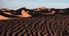 The Rubʽ al-Khali sand desert, most of which lies within Saudi Arabia.Lynn Abercrombie
* * *
Introductiongreat desert region occupying almost the entire Arabian Peninsula. Covering an area of about 900,000 square miles (2,300,000 square km), it is bordered on the north by the Syrian Desert, on the northeast and east by the Persian Gulf and the Gulf of Oman (Oman, Gulf of), on the southeast and south by the Arabian Sea and the Gulf of Aden (Aden, Gulf of), and on the west by the Red Sea. A large part of the Arabian Desert lies within the modern kingdom of Saudi Arabia. Yemen, on the coast of the Gulf of Aden and the Red Sea, borders the desert to the southwest. Oman, bulging out into the Gulf of Oman, lies at the eastern edge of the desert. The sheikhdoms of the United Arab Emirates and Qatar to the west stretch along the southern coast of the Persian Gulf at the desert's northern limit. The emirate of Kuwait abuts the northern Persian Gulf between Saudi Arabia and Iraq. In the northwest the desert extends into Jordan.Seen from the air, the Arabian Desert appears as a vast expanse of light sand-coloured terrain with an occasional indistinct line of escarpments or mountain ranges, black lava flows, or reddish systems of desert dunes stretching to the horizon. Camel trails crisscross the surface between watering places. On the ground, features become distinctly individual and the relief seems more prominent. Vegetation at first seems nonexistent, but the discerning eye can find sparse patches of growth on the surface, or bits of green where shrubs strive to survive. There is almost always a breeze, which changes seasonally to winds of gale force. Cold or hot, these air currents chill the body or roast it. The Sun and Moon are bright in clear skies, although dust and humidity may lower visibility.Physical featuresWestern Arabia formed part of the African landmass before a rift occurred in the Earth's crust, as a result of which the Red Sea was formed and Africa and the Arabian Peninsula finally became separated some five to six million years ago. Thus, the southern half of the peninsula has a greater affinity with the regions of Somalia and Ethiopia in Africa than with northern Arabia or the rest of Asia. The northern Arabian Desert merges imperceptibly into Arab Asia through the Syrian steppe (treeless plain). The bulge of Oman contains mountain ranges that formed when oceanic crust accumulated on the Arabian plate as it moved northeastward. The peninsula measures about 1,300 miles (2,100 km) in length, from northwest to southeast; its width, from the Red Sea to the Gulf of Oman or Persian Gulf, ranges from about 700 miles (1,100 km) across central Saudi Arabia to some 1,250 miles (2,000 km) in the south between Yemen and Oman.Three corners have high elevations: the southwestern corner in Yemen, where Mount Al-Nabī Shuʿayb reaches the desert's highest elevation, 12,336 feet (3,760 metres); the northwestern corner in Hejaz (a part of Saudi Arabia), where Mount Al-Lawz rises to 8,464 feet (2,580 metres); and the southeastern corner in Oman, where Mount Al-Shām attains an elevation of 9,957 feet (3,035 metres). Much of the Yemen Plateau is at an elevation above 7,000 feet (2,100 metres). To the north and east elevations decrease. Steep cliffs and steep canyons descend from the highlands into adjacent seas to the south and west. The peninsula is bounded on its western margin by a great escarpment, stretching more than 600 miles (1,000 km) from Yemen into Saudi Arabia. It is the most striking feature of the Red Sea margin, rising abruptly from an elevation of roughly 600 feet (200 metres) to greater than 3,300 feet (1,000 metres). South of Al-Ṭāʾif, near Mecca, the escarpment is rugged and dissected into short, steep canyons and ridges. At the foot of the scarp, the Tihāmah plain slopes to the sea; at Mount Sawdāʾ, near Abhā in the Asir region, the drop is about 9,000 feet (2,700 metres) in six miles. In Oman, northeastern slopes are short and steep, but on the southwest flanks the slopes grade gently to the Rubʿ al-Khali desert basin. The southern plateau is cut by great steep-walled canyons into rugged limestone masses that have kept the peoples of that region isolated for centuries.The rest of the peninsula displays a moderate relief characterized by broad plains. At least one-third is covered by sand. North of Al-Ṭāʾif (Ṭāʾif, Al-) the Hejaz and Najd plateaus seldom rise above 3,600 feet (1,100 metres), except where volcanic fields occur or where remnants of the crystalline rocks that underlie the region rise to the surface. The slope to the Persian Gulf averages eight feet per mile (1.5 metres per kilometre).GeologyThe Arabian Desert consists of two major regions. The first, the ancient Arabian platform (a segment of the African Shield) is in the west; composed mainly of Precambrian gneiss dated to between 2.6 billion and roughly 543 million years ago, it was assembled roughly 900 to 543 million years ago. The second region, in the east, comprises sedimentary rock layers deposited over the past 543 million years on continental shelves and within marine basins along the margins of the Arabian platform. Vast amounts of petroleum formed between these sedimentary rock layers, making this the richest petroleum-producing region in the world. Roughly 33 million years ago, during the Oligocene Epoch, Arabia began to split away from Africa. This was the onset of a period of rifting that was caused by upwelling from the Earth's mantle beneath the regions now lying on either side of the Red Sea. Between 30 and 20 million years ago, rising magma flowed to the surface as lava to produce flood basalts (igneous rock) reaching thicknesses as great as 9,800 feet (3,000 metres). These flood basalts now form large parts of the high mountains along the Red Sea margin in Yemen. Volcanism has continued on a lesser scale into the Holocene Epoch (the last 10,000 years). The upwelling magma caused the region to dome and rise. This thinned and extended the crust to produce extensive fault systems along the Red Sea margin. By about 5 to 6 million years ago, rifting had progressed so much that oceanic crust began to form in the Red Sea to produce a proto-ocean (the early stage of a new ocean). Throughout this period of rifting, the Arabian plate has rotated progressively northward to collide with the Eurasian plate. This has caused the Persian Gulf to narrow, has scooped ocean crust from the Gulf of Oman onto the Arabian plate to form the mountains of Oman, and has compressed the Eurasian plate to form the Zagros Mountains in Iran.PhysiographyMountainous highlands rise in the northwestern portion of the Hejaz region, in the Asir region, in Yemen, and in Oman. Lesser ranges have been uncovered by erosion in the interior. Eighteen volcanic fields are scattered through the west, mainly in Hejaz, several of them more than 10,000 square miles (25,000 square km) in area.Plateaus are a common desert feature. Jordan east of the Dead Sea forms a moderately elevated plateau. To the southeast, Mount Al-Ṭubayq rises higher, standing as a mass of sandstone deeply cut by numerous wadis (ephemeral watercourses). Farther southeast the plateaus of Tabūk, Taymāʾ, Ṭawīl, Al-Ḥufrah, and Al-Hūj reach to the western edge of Al-Nafūd (Nafūd, An-) (Great Nafud), a sand desert in the north. Through central Najd, a highland region southeast of Al-Nafūd, a series of west-facing scarps are formed by cuestas (cuesta) (low ridges with steep faces on one side and gentle slopes on the other) of limestone reaching to highlands of the Hadhramaut in the south, where the plateau of Al-Jawl (Jol) is located. The Ṭuwayq Mountains are the most prominent of these cuestas.Below the plateaus spread broad plains. Covered with chert (chert and flint), other rocks, or gravel, their surfaces are well preserved under the arid climate. Some plains are duricrusted (covered with a crust of soil formed by salts), having smooth, firm surfaces formed by the cementation of sandy debris at groundwater level. Typical of the stony plains is Al-Ḥamād, which stretches from Al-Nafūd northward into the Syrian Desert. Chert plains were formed on the surface during the Oligocene in the Al-Ḥamād and in the Al-Malsūniyyah region east of the Khurayṣ oil field. The gravel plains resulted from deposits left during the Pleistocene Epoch (1,800,000 to 10,000 years ago) by ancient river systems now represented by such wadis as Al-Rimah–Al-Bāṭin, Al-Sahbāʾ, and Dawāsir-Jawb, which carried vast loads of sediment from the interior toward the Persian Gulf. The Al-Dibdibah region once was the delta of Wadi Al-Rimah–Al-Bāṭin, and Al-Budūʿ Plain was the delta of Wadi Al-Sahbāʾ. The gravel plains of Raydāʾ and Abū Baḥr, and adjacent areas covered by sand, formed the delta of the Dawāsir-Jawb system. Several of the deltas formed by these ancient rivers are as large in area as the delta of the Nile River. The northern Al-Ṣummān Plateau is smooth where it emerges from under Al-Dibdibah gravels. Farther south, the surface is eroded into many closed basins.Upwelling beneath the western margin of the Arabian platform has tilted it northeastward, creating a prominent regional divide along its western rim from Yemen to Jordan. In the south another regional divide separates the coastal drainage of Hadhramaut from the Wadi Ḥaḍramawt system inland, and a third system, also in the south, divides the Al-Jawl region from the system draining into the Rubʿ al-Khali. The Oman Mountains divide short, steeply graded, northeast-sloping wadis from the less steep wadis sloping southwest into the eastern Rubʿ al-Khali.Lesser divides enclose basins in Hejaz, Najd, and Jordan. Four adjacent interior basins lie in the platform between latitudes 21° and 26° N. Others occur in the Tabūk area, in the Wadi Al-Sirḥān, at the Al-Jafr Depression in southern Jordan, and in the Jordan–Dead Sea depressions. Hundreds of smaller basins, seldom larger than 4 to 8 miles (6 to 13 km) in diameter, are found in volcanic fields, in the shield, and in many poorly drained areas of sedimentary rocks. A few of these small basins are saline, but the vast majority are floored by silts deposited in thin layers.Most drainage channels in the Arabian Desert are either dry or ephemeral, flowing only when rains are heavy. Two systems flow perennially in the region—the Tigris and Euphrates (Tigris-Euphrates river system) rivers and Wadi Ḥajr in the southern Hadhramaut region. The main drainage systems of Al-Widyān, Al-Rimah–Al-Bāṭin, Al-Sahbāʾ, and the Dawāsir-Jawb were the scenes of great Pleistocene floods (flood). Today floods are infrequent but no less destructive; they seldom, however, reach the desert sands where the channels have been dammed. The directions taken by several large systems have been altered by stronger streams that have intercepted them, including Wadi Jizl-Ḥamḍ in northern Hejaz and Wadi Ḥaḍramawt in the south.Where they enter large expanses of sand, wadis lose their identities. The alluvium carried in flood time is added to the sand body and redistributed by the wind. About two-thirds of the Arabian Desert is drained by complete wadi systems. The intermittent action of running water is more effective than the erosive action of the winds in shaping the landscape. The main exceptions to this are the formation of sand dunes and the grooving of rocks by wind-borne sand.One of the special features of eastern Arabia is the sabkhah (or sebkha; saline flat), which usually is a gently sloping sandy plain located along the coast on which salt brine has been concentrated at or just below the surface. It is formed by the filling of embayments with sand—a process that continues as the sea level retreats—while the high rate of evaporation concentrates the trapped seawater to strong brine. Scouring of the sandy surface by shamal (north to northwest) winds exposes the salty crust, which may then be dissolved into brine by winter rains. High tides may spread the saline surface waters inland. The salt crust does not usually attain a thickness of more than three feet (one metre). It may be interbedded with sand, silt, mud, or other deposits formed by evaporation, such as gypsum. The surface of Sabkhah Maṭṭī, the largest single exposed sabkhah, is sometimes composed of soft, wet, muddy, and salty slush, with a hard crust less than three feet (one metre) deep. It is very treacherous to unwary travelers. The sabkhah surface is not akin to quicksand, but its danger lies in the inability of the traveler to recognize its nature in time to avoid sinking into a morass. Northwest of the oil refinery at Ras Tanura, sabkhahs carry a thin crust of salt and sand, underlain by soft calcareous (chalky) mud that is formed in shallow tidal flats by algae and eventually is covered by sand or salt. This mud has the consistency of custard. The eastern Rubʿ al-Khali has a broad sabkhah floor that rises to nearly 330 feet (100 metres), which seems to be the highest elevation that sabkhahs attain.Saline basins develop in enclosed valleys, either from the evaporation of floodwaters bearing dissolved minerals or—more usually—from the evaporation of saline waters nurtured by nearby outcrops of salt. The Arabic name for this kind of salt flat is mamlaḥah. Arabs have quarried crude salt from both sabkhahs and mamlaḥahs for hundreds of years.The sand cover of the Arabian Desert occurs as dunes (sand dune) of varying size and complexity or as a thin film on surfaces of lower relief. With few exceptions, sand does not accumulate in flat sheets but in dunes, ridges, or giant complexes. The variety of dune shapes and sizes in the Arabian Desert is legion. Many forms have not even been described in print. Contrary to statements by early European explorers that there is nothing but a shapeless sea of sand, the sand desert develops along systematic lines with distinct and characteristic patterns. There are also clear-cut genetic relationships between dunes in adjacent areas. In such huge sand (sand dune) areas as the Rubʿ al-Khali, the evolution of dune forms can be traced from simple dunes into the more complex types.The two largest sand bodies in Arabia are Al-Nafūd (Nafūd, An-) in the northwest and the Rubʿ al-Khali (Al-Ramlah) in the southeast. Al-Nafūd has an area of 25,000 square miles (65,000 square km); the Rubʿ al-Khali has an area of 250,000 square miles (650,000 square km). Between them are two almost parallel arcs of more or less continuous dunes. The outer arc, convex to the east, is Al-Dahnāʾ, about 750 miles (1,200 km) long and from 6 to 50 miles (10 to 80 km) wide. The inner arc, shorter and less continuous, includes six elongated nafūds situated in low areas between the west-facing limestone escarpments of the central Najd. The two major arcs are separated by the Ṭuwayq Mountains. Al-Dahnāʾ connects with Al-Nafūd in the northwest and with the Rubʿ al-Khali in the southwest. The inner belt grows more disconnected south of latitude 24° N and dies out before reaching Wadi Al-Dawāsir.Al-Nafūd fills an irregular basin surrounded by hills, ridges, and buttes (butte) (isolated flat-topped hills rising abruptly from the surrounding land) or mesas (mesa) (table-topped plateaus of relatively small extent with steep rock walls). Its sand was eroded and carried by winds from outcrops of sandstone that lie west and northwest. Al-Nafūd is characterized by a unique dune form, a giant crescent slipface (the slope on the leeside of the dune that approximates the angle of rest of loose sand, usually about 32°) moving through a thick mass of loose sand. The lee hollow in front of the slipface consists of bedrock, barren of sand. The impression obtained from an aerial view is of hooflike hollows, which extend from the southwest edge, well across Al-Nafūd. Along other margins of the desert and through the centre are seif (linear) and pyramidal dunes. Al-Nafūd has been a barrier to travel for ages; only rarely have non-Arabs ventured there. A caravan route runs from northwest to southeast connecting the oases of Al-Jawf (Jawf, Al-) with those of Ḥāʾil. The topographic relief of dunes in Al-Nafūd may exceed 300 feet (90 metres).With an area exceeding that of France, Rubʿ al-Khali displays a variety of dune forms that appears to be unique, although parts of the Sahara show many similar dunes as well as a few that are different. The name Rubʿ al-Khali (“The Empty Quarter”) is not usually used by the Bedouins who travel over it; instead they refer to it as Al-Ramlah (“The Sand”). The Rubʿ al-Khali has five general types of sand terrains: barchan (crescentic) or transverse; seif; giant dune complexes, or “sand mountains,” that take the shapes of domes, pyramids, huge crescents, and sigmoidal (S-shaped) ridges; hook-shaped dunes; and dunes with vegetation and moisture. The eastern Rubʿ al-Khali fills a broad shallow basin floored mainly by sabkhahs that slope toward the southern shores of the Persian Gulf. The floor west of the 51st meridian rises to the southwest to nearly 3,600 feet (1,100 metres) and consists largely of gravel plains. Highlands surround this sand desert on the northeast, south, and west. The greatest volumes of sand lie in belts within the eastern basin. These belts appear to have accumulated during the Pleistocene in several stages as sea levels rose and fell.Al-Sabʿatayn Dunes in north-central Yemen, in the lowland south of the western border of the Rubʿ al-Khali, cover an area of about 60 by 150 miles (100 by 240 km), or roughly 10,000 square miles (26,000 square km). Al-Sabʿatayn comprises mainly transverse and seif dunes.Āl Wahībah Dunes are located near the extreme eastern cape of the peninsula. An oblong dune field 60 by 100 miles (100 by 160 km) wide, the area is made up of linear ridges and interdune valleys oriented almost exactly north and south.An elongated sand body named ʿUrūq Subayʿ (ʿurūq is an Arabic word for a region of sand dunes) lies in the southern part of the Wadi Al-Rimah basin. ʿIrq al-Subayʿ (ʿirq is the singular form of ‘urūq), northwest of Riyadh in Najd, dams the middle Wadi Al-Jarab drainage system. A small cluster of broad transverse dunes has formed on the south coast east of the port of Aden.ClimateThe Arabian Desert spreads across 22° of latitude, from the 12th to the 34th parallel north; although much of the desert lies north of the Tropic of Cancer, it usually is considered a tropical desert. Summer heat is intense, reaching temperatures as high as 129 °F (54 °C) in places. In the interior the heat is dry. Coastal regions and some highlands, however, are subject to high summer humidity, with dew and fog at night or early morning. Rainfall throughout the desert averages less than 4 inches (100 mm) a year but can range from 0 to 20 inches (0 to 500 mm). Interior skies are usually clear except for intermittent winter rains, spring hazes, or dust storms. Torrential rains flood the main drainage basins infrequently. Winters are invigoratingly cool, with the coldest weather occurring at high altitudes and in the far north. A minimum temperature recorded at Ṭurayf on Tapline (the Trans-Arabian Pipeline) in 1950 was 10 °F (−12 °C) and was accompanied by several inches of snow and an inch of ice on ponds. Occasional summer rains in the Rubʿ al-Khali accompany the monsoon winds from the Indian Ocean. Winter rains may occur in the northern Rubʿ al-Khali. The most arid part of the Arabian Desert appears to be on the western margin of the Rubʿ al-Khali, north of Wadi Al-Dawāsir.The prevailing winds blow from the Mediterranean, swinging to the east, southeast, south, and southwest in a great arc. Two semiannual windy seasons occur—one from December to January, the other from May to June. Called shamals (shamal) (from the Arabic shamāl: “north”), these periods last from 30 to 50 days and have wind velocities averaging 30 miles per hour (48 km per hour). Shamals, which try the patience of those caught in them, are dry winds that transport huge loads of sand and dust and alter the shapes of sand dunes. Millions of tons of sand are carried by each storm into the Rubʿ al-Khali. Blown sand does not rise more than a few feet (a metre or two) above the surface, except when picked up by whirlwinds, dust devils (jinn), or regional sandstorms. Winds blow from all directions in central Najd and in the southeastern Rubʿ al-Khali. Strong southeast gales sweep the big sand desert for several days at a time, reversing the effect of shamals on dune formation. Nevertheless, the power of desert winds to excavate basins is much exaggerated. The wind is important as an agent of erosion but, as mentioned above, is never as effective as running water is in modifying the surface of the land.The sudden appearance on the horizon of the “brown roller” in spring or fall can be frightening. A frontal storm up to 60 miles (100 km) wide carrying sand, dust, and debris high into the air, it is followed by a sharp drop in temperature and often by rain. Wind velocities often reach gale force for half an hour or so. Hot days produce myriads of dust devils and the ill-famed mirage.SoilsMechanical weathering, which physically breaks down coarse particles into finer grains, is the most significant process in the formation of desert soils. Quartz sand abounds, covering more than a third of the desert surface. Granular debris from the Precambrian crystalline basement forms pebbly fans about the bases of hills. Sands and silts are washed down to lower levels and are then winnowed out by winds. Fine materials grade down to silt. Smaller particles, such as clays, rarely form. Limestone, when pulverized, forms silt-sized dusts. Waterborne silts eventually are deposited in khabari, or silt flats.Because the soils have proved to be fertile, irrigated silt flats are farmed. Najd villages that once depended on November rains to raise their winter wheat now irrigate and farm year-round; but overgrazing near government-provided wells has led to serious deterioration of rangeland in the Najd. The valleys and lower slopes of the Yemen and Asir highlands are extensively terraced for soil and water conservation and produce many crops, of which coffee is important in local markets. These soils are derived from crystalline rocks of high mineral content. Salt flats in the desert—though too salty for many crops—can be cultivated if they are irrigated and drained properly. In addition, many plants, called halophytes, grow in saline soils. The date palm thrives on salty soils if properly irrigated and drained.Desert dune sands are generally dry but can hold rainfall to depths of three feet (one metre) or more, thus nourishing xerophytes (plants adapted to survive under arid conditions). Shrubs unique to the area, called ʿabl and ghaḍā, send out long, shallow roots to catch the slightest bit of moisture. These roots make good firewood.Plant lifeThere is a great variety of desert flora. Plants are primarily xerophytic (structurally adapted to a limited water supply) or halophytic (salt-tolerant). After spring rains, long-buried seeds germinate and bloom in a few hours. The normally barren gravel plains turn green. Even chert plains produce late-winter and early-spring grazing for camels and sheep. The plains were once the home of the famed Arabian horse, but grazing was always too poor to support a large horse population. Certainly all the grazing areas were overgrazed, thus contributing to the formation of the present widespread barren tracts. The halophytes growing on the saline flats include many succulents and fibrous plants that can be eaten by camels. Sedge, which grows in sandy areas, is a tough plant with deep roots that help to hold down the soil. The tamarisk tree is often found on the borders of oases, where it helps to prevent the encroachment of sand.Flowering plants in central Arabia include examples of the convolvulus, mustard, pea, daisy, caper, iris, and milkweed families. These plants produce seeds in the cooler months, when the annuals go through their entire life cycle.Because its twigs traditionally are used by Arabs to polish their teeth, the rare shrub rāq, or arāq, is known as the “tooth-brush bush.” Many herbs grow throughout the desert and are well known to the Bedouin, who use them for seasoning, preserving food, perfuming clothing, and washing hair. Shrubs that yield the fragrant frankincense and myrrh are found in the lower elevations of the Dhofar region of Oman. The eastern Rubʿ al-Khali, generally thought to be dry and barren, supports much plant life on flanks of giant dunes, including a sweet grass called naṣī that provides the main forage for the now-rare oryx (a species of African antelope).There are no cacti in the Old World, except for those imported from the Americas. One of these imports, the prickly pear, thrives and is fed to livestock. Moreover, its fruit is eaten by people. Spiny and thorny plants also are common, including the euphorbia, a plant with milky juice and flowers with no petals that grows in Hejaz, and the camel thorn, found everywhere. Acacia trees were once abundant in the Ṭuwayq Mountains, but the demand for charcoal decimated them. The few growing in wadis and gardens provide welcome shade. Junipers reach great size in the highlands of Asir and Yemen. Their trunks are cut into the beams and pillars that characterize the region's architecture. The milkweed tree (ishar) grows to a height of 20 feet (6 metres) in Wadi Al-Bāṭin and is common in the wadis of Najd and in Wadi Bīshah.The date palm, of which there are numerous varieties, is grown in many oases, with the dates themselves providing food for humans and livestock. The palm supplies wood for building and for making water-well frames and pulley shafts of ancient type; its fronds are used for handicrafts and for thatching roofs. The oases also produce many fruits and vegetables such as rice, alfalfa, henna (a shrub that yields a reddish orange dye), citrus, melons, onions, tomatoes, barley, wheat, and—in higher regions—peaches, grapes, and prickly pears.Animal lifeThe animal life is varied and unique. Desert insects include the fly, the malaria-carrying Anopheles mosquito, fleas, lice, roaches, ants, termites, beetles, and mantids (predatory insects that camouflage themselves as leaves, twigs, or pebbles). Also found are the scavenging dung beetle, myriads of butterflies, moths, and caterpillars, and the pestiferous locust that once plagued the landscape but has now been brought under control.Arachnida (a class of segmented invertebrates) include large sapulgids (scorpion-killers), scorpions, ticks, and spiders. Sapulgids grow to eight inches (20 cm) in length. Scorpions also range up to eight inches and are coloured black, green, yellow, red, and off-white. The scorpion's painful sting is deadly to small children.Pools in oases contain small fish. There are a few amphibious animals, such as newts, salamanders, toads, and frogs. Reptiles include lizards, snakes, and turtles. The dab (or dabb), a fat-tailed lizard, lives on the plains and reaches a length of up to three and a half feet (more than one metre). It is a vegetarian with toothless jaws, and its tail, roasted, is a Bedouin delicacy. The monitor lizard reaches lengths up to three feet (nearly one metre) and feeds on locusts and other insects. Many lizards, including skinks, geckos, agamids, and collared lizards, are found in the sand. Lively and pretty, a salmon-coloured lizard, the dammūsa seeks the black beetle for food and literally dives and swims in the slipfaces of the sand dunes. An agamid lizard (ṭuḥayḥī) scurries across the sand with its tail coiled like a watch spring, uncoiling when it stops.Among the snakes, all of which are feared by most Arabs, the sand cobra—relative of the sea snake—is slim, sand-coloured, and venomous. Vipers abound in sand and rocks but, being nocturnal, are seldom seen in the heat of day.Birds of the Arabian Desert include local species as well as migrant groups from northern Europe, Africa, and India. The local birds breed from late winter to early spring. Many of the young display excellent camouflage. The bifasciated (striped) lark, the sand grouse, the Arabian courser, and the lesser bustard live in the desert year-round, as do several falcons, eagles, and vultures. The peregrine falcon is seen in Asir, saker and lanner falcons (a brown falcon with a golden cap) are found in Najd and eastern Saudi Arabia, and the kestrel is everywhere. The saker falcon (an aggressive, light brown falcon) is often captured young and trained by Bedouin falconers to hunt the bustard and sand grouse. Ravens in pairs or flocks may appear anywhere. Three eagle species are known—the white-tailed, golden, and tawny eagles. Vultures were more numerous when camels were in greater use. The largest, a black species with a wingspread of up to 9 feet (2.7 metres), has nearly disappeared. The Egyptian vulture (ar-rakhamah), a medium-sized white-and-black bird with yellow markings, is widely distributed. The lammergeier (bearded vulture) lives in Asir and Yemen. There also are several owls, among which a burrowing species is common.Migrant birds follow several flyways, one through the central Najd and others on each coast. Water and shore birds migrate in fall and spring between northern Europe and the tropics. Bee eaters, warblers, babblers, carrion kites, swallows, martins, swifts, wheatears, shrikes, larks, flycatchers, hoopoes, and some exotic species may be seen alone, in pairs, or in flocks. Cranes, herons, flamingos, ducks, and small wading birds feed on shores and in the intermittent lakes. The ostrich, once abundant in the sand deserts, has been extinct since 1940.Mammals were numerous before the Arabs hunted them from motor vehicles. Gazelles roamed the plains in herds of hundreds before World War II and afterward almost became extinct, until the Saudi government began to regulate hunting and established wildlife preserves. The oryx, which nearly had disappeared by 1960, was reintroduced after having been bred in captivity. The ibex, a cliff-dwelling species of wild goat, has begun to recover after its numbers were decimated. In desert plains the ratel (a badgerlike carnivore), the fox, and the civet live in territorial isolation. The hyena lives wherever sheep are herded, preferring escarpments that provide cover. Jackals also are seen, especially at dusk when they seek water. There are hares, as well as golden sand rabbits. Small rodents include the jerboa, mice, rats, and porcupines, while small hedgehogs are found among rocks. Troops of baboons roam in Asir.PeoplePeople have inhabited the Arabian Desert since early Pleistocene times. Artifacts have been found widely, including at Neolithic sites in Qatar and Dubai, but are most abundant in the southwestern Rubʿ al-Khali. Archaeological research sponsored by the Saudi government has uncovered many Paleolithic sites. Remains of cultures from the past 3,000 years occur in many parts of the peninsula.The Bedouin adapted to nomadic desert life by breeding camels, Arabian horses, and sheep; but they have also grown date palms and other crops, usually hiring others to perform agricultural labour. Traditionally, finding grazing and water were the main concerns of the Bedouin, in addition to raiding to seize horses and camels. Nomads (nomadism) also interacted with the settled population through religious rituals (e.g., the pilgrimage to Mecca), long-distance commerce, and the exchange of poetry and other cultural activities. Hereditary tribal Bedouin groups claimed certain lands as their dirah (tribal territory), where their flocks could graze and water. As international boundaries were drawn in the desert, governments increasingly limited tribal mobility. Saudi authorities encouraged the Bedouin to settle in oases, and after 1925 the Saudi ruler ʿAbd al-ʿAzīz (generally known as Ibn Saʿūd) prevented intertribal raiding. Tribal loyalties have declined in political importance but have remained significant in such areas as marriage. Modernization has brought much change, particularly for those Bedouin who have settled. Many have moved to urban areas, and the number of purely nomadic people is now only a small proportion of the desert's total population; other former nomads have settled in or near desert villages, thereby keeping open the option of part-time nomadism.Western cultural influence accelerated with the discovery of petroleum in 1936 and led to the introduction of such modern conveniences as airplanes, telephones, and televisions. Trucks have been of particular importance for the Bedouin, who use them for many purposes, including transporting sheep to market, moving fodder and water to sites where animals raised for meat are herded, moving small numbers of animals from one grazing area to another, and traveling between cities and villages. Increased mobility has meant that, while fewer Bedouin children attend schools than the children of settled peoples, the nomads have begun to gain greater access to education and other public services. Women remain mostly in the home, but Bedouin men often travel great distances to find work; most families derive some income from relatives who serve in the military.EconomyResourcesThe greatest natural resource of the Arabian Desert is its underground water supply, which—as it remains virtually unreplenished because of low rainfall—in effect consists of Pleistocene-age waters that are now being tapped. Modern techniques have been used by the governments of Arab countries to develop water sources and to irrigate soils for farming. Desalinization plants built along the coasts produce great quantities of fresh water from seawater, making the Arabian Peninsula one of the leading regions of the world employing this technology.As mentioned above, petroleum was found in 1936 in eastern Saudi Arabia, but commercial production did not begin until 1938. Since World War II many new oil fields and refineries have been brought into operation throughout the region; their production potential is measured in the millions of barrels per day, and reserves are enormous. Reserves of natural gas also have been exploited on a large scale. Although output levels generally have been high, they have been subject to fluctuations in world oil markets and to political turmoil in the region—notably the Persian Gulf War in 1990–91.Building materials in use before the mid-20th century included stone, adobe, a crude cement made from impure calcareous rock taken from the floor of the Persian Gulf, and the wood of the date palm and juniper. Modern construction utilizes steel, concrete, light alloys, imported lumber, local stone—especially granites, marbles, and limestone—and slates from Hejaz. Salt and gypsum are produced from saline flats.TransportationTravel today in the Arabian Desert is easy and rapid. Instead of the slow camel caravan, automobiles now roar across desert terrains. Jets fly overhead, and the railroad from Al-Dammām (Dammām, Al-) on the Persian Gulf to Riyadh covers the distance in a few hours. Paved, multilane highways cross the desert and link the chief Saudi cities, while narrower roads connect almost all towns and villages to the national network. New roads have been built into Asir, making that province and its fine agricultural produce accessible to urban markets. A Saudi Arabian government-owned airline offers flights between towns in different regions of the desert.About four-fifths of the Arabian Desert is accessible to cars, regardless of roads. Essential equipment includes sand tires, two-way radios, and the capacity to carry fuel, food, and water, as well as spare parts and camping gear.Study and exploration (European exploration)Before the 18th century many Arabs but few Europeans had succeeded in penetrating the Arabian Desert, and few authors had written about it. Travel literature written in Arabic concentrated on the routes taken by pilgrimage caravans going to Mecca. Scientific exploration began in 1762 with a Danish expedition led by the German surveyor Carsten Niebuhr (Niebuhr, Carsten). In the 19th century British officers of the Indian colonial government undertook surveys of the surrounding seas and coasts.The first important modern work on the geography of Arabia, Travels in Arabia Deserta (1888), was written by English traveler Charles M. Doughty (Doughty, Charles Montagu). At the turn of the 20th century, Czech explorer Alois Musil traveled through northern Hejaz and Najd, mapping topography as he went. In 1917 H. St. John Philby (Philby, H. Saint John), an official of the British Foreign Office who paid a visit to the sultan of Najd (later Ibn Saʿūd of Saudi Arabia), later became a Muslim, settled in Riyadh as a counselor to Ibn Saʿūd, and explored the Arabian Desert, writing detailed and accurate accounts of his travels. Another British official, T.E. Lawrence (Lawrence, T E) (“Lawrence of Arabia”), who was an adviser to the Arabs during their World War I revolt, gained fame for his romantic writings about his exploits in the region. Many individuals traveled in limited parts of the desert; the most notable among them was British traveler Wilfred Thesiger, who crisscrossed the Rubʿ al-Khali after World War II.After World War II, geographic and geologic exploration intensified and was accompanied by vast aerial photographic surveys, from which the first accurate maps of the peninsula were prepared and published between 1956 and 1965. The countries of the region subsequently have undertaken other surveys of the land and its mineral resources.Additional ReadingDescriptive surveys of the Arabian Desert include Wilfred Thesiger, Arabian Sands (1959, reprinted 1991), a modern classic; Colbert C. Held, Middle East Patterns: Places, Peoples, and Politics, 2nd ed. (1994), with a general geography of Southwest Asia; and accounts of important travels in the region, such as Charles M. Doughty, Travels in Arabia Deserta, new and definitive ed., 2 vol. in 1 (1936, reprinted in 2 vol. 1979); T.E. Lawrence, Seven Pillars of Wisdom (1935, reissued 1991); and H.St.J.B. Philby, The Empty Quarter: Being a Description of the Great South Desert of Arabia Known as Rubʾ al Khali (1933, reprinted 1986), and Arabian Highlands (1952, reprinted 1976). Two valuable works on the flora and fauna are Betty A. Lipscombe Vincett, Wild Flowers of Central Saudi Arabia (1977); and Abdul Monʿim S. Talhouk et al., The Wildlife of Arabia (1981). A.R. Al-Ansary, Qaryat al-Fau: A Portrait of Pre-Islamic Civilisation in Saudi Arabia (1982), discusses early patterns of settlement in the desert. Norman Anderson et al., The Kingdom of Saudi Arabia, 9th ed. (1993), contains a number of useful studies. H.R.P. Dickson, The Arab of the Desert, 3rd ed., rev. and abridged, ed. by Robert Wilson and Zahra Freeth (1983), discusses Bedouin culture and custom prior to 1940. The impact of modernization on the peoples of the desert areas is addressed by Donald Powell Cole, Nomads of the Nomads: The Āl Murrah Bedouin of the Empty Quarter (1975); Motoko Katakura, Bedouin Village: A Study of a Saudi Arabian People in Transition (1977); and Soraya Altorki and Donald P. Cole, Arabian Oasis City: The Transformation of ʿUnayzah (1989). Useful sources on the geological evolution of Arabia include Ian Davison et al., “Geological Evolution of the Southeastern Red Sea Rift Margin, Republic of Yemen,” Geological Society of America Bulletin, 106:1474–1493 (November 1994); and Martin J. Whitehouse et al., “Crustal Evolution and Terrane Correlation in the Eastern Arabian Shield, Yemen: Geochronological Constraints,” Journal of the Geological Society, London, 155:281–295, (1998).Lewis Owen* * *
Universalium. 2010.