Hadrian's Wall — n. stone wall across N England, from Solway Firth to the Tyne: built (A.D. 122 128) by Hadrian to protect Roman Britain from N tribes: 73.5 mi (118.3 km) … English World dictionary
Hadrian's Wall — This article is about the fortification in Northern England. For the Broad Wall of Jerusalem, see Broad Wall (Jerusalem). Coordinates: 55°01′27″N 2°17′33″W / 55.02417°N 2 … Wikipedia
Hadrian's Wall — a wall of defense for the Roman province of Britain, constructed by Hadrian between Solway Firth and the mouth of the Tyne. * * * Continuous Roman defensive barrier. Begun by Hadrian in AD 122, the wall guarded the northwestern frontier of the… … Universalium
Hadrian's Wall — noun an ancient Roman wall built by Hadrian in the 2nd century; marked the northern boundary of the Roman Empire in Britain • Instance Hypernyms: ↑wall • Part Holonyms: ↑England * * * Hadrian’s Wall [Hadrians Wall] a wall in northern England… … Useful english dictionary
Hadrian’s Wall — Sp Hadriãno siena Ap Hadrian’s Wall L ist. paminklas D. Britanijoje (Anglijoje) … Pasaulio vietovardžiai. Internetinė duomenų bazė
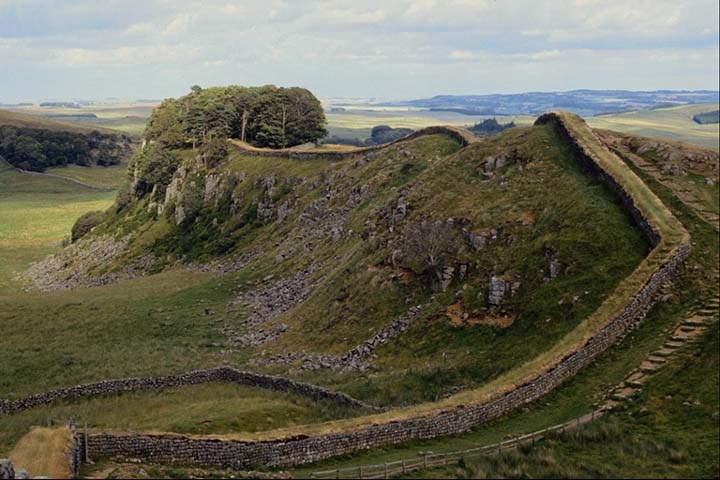
Hadrian's Wall Path — Infobox Hiking trail Name=Hadrian s Wall Path Photo=Hadrians wall craigs.jpg|thumb|200px|] Caption=Crag Lough, near Steel Rigg on the Path Location=England: Tyne and Wear, Northumberland, Cumbria Designation=National Trail Length=Convert|84|mi|0… … Wikipedia
Hadrian’s Wall Path — Der Hadrian´s Wall Path ist ein Fernwanderweg im Norden Englands unweit der Grenze zu Schottland. Der Weg verläuft zwischen Wallsend an der Ostküste und Bowness on Solway an der Westküste vorbei an Städten wie Newcastle upon Tyne und Carlisle.… … Deutsch Wikipedia
Hadrian's Wall Path — Der Hadrian´s Wall Path ist ein Fernwanderweg im Norden Englands unweit der Grenze zu Schottland. Der Weg verläuft zwischen Wallsend an der Ostküste und Bowness on Solway an der Westküste vorbei an Städten wie Newcastle upon Tyne und Carlisle.… … Deutsch Wikipedia
Hadrian's Wall — Ha|dri|an s Wall a stone wall which the Roman ↑emperor Hadrian ordered to be built across the north of England in 122 AD from the east coast to the west, in order to defend Roman Britain from attack by northern tribes such as the Picts … Dictionary of contemporary English
Hadrian's Wall — Ha′drian s Wall′ n. anh why a wall of defense for the Roman province of Britain, built by Hadrian between Solway Firth and the mouth of the Tyne … From formal English to slang