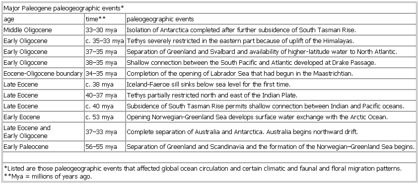
- Major Paleogene paleogeographic events
-
▪ TableMajor Paleogene paleogeographic events*age time** paleogeographic eventsMiddle Oligocene 33–30 mya Isolation of Antarctica completed after further subsidence of South Tasman Rise.Early Oligocene c. 35–33 mya Tethys severely restricted in the eastern part because of uplift of the Himalayas.Early Oligocene 37–35 mya Separation of Greenland and Svalbard and availability of higher-latitude water to North Atlantic.Early Oligocene 38–35 mya Shallow connection between the South Pacific and Atlantic developed at Drake Passage.Eocene-Oligocene boundary 34–35 mya Completion of the opening of Labrador Sea that had begun in the Maastrichtian.Late Eocene c. 38 mya Iceland-Faeroe sill sinks below sea level for the first time.Late Eocene 40–37 mya Tethys partially restricted north and east of the Indian Plate.Late Eocene c. 40 mya Subsidence of South Tasman Rise permits shallow connection between Indian and Pacific oceans.Early Eocene c. 53 mya Opening Norwegian-Greenland Sea develops surface water exchange with the Arctic Ocean.Late Eocene andEarly Oligocene 37–33 mya Complete separation of Australia and Antarctica. Australia begins northward drift.Early Paleocene 56–55 mya Separation of Greenland and Scandinavia and the formation of the Norwegian–Greenland Sea begins.*Listed are those paleogeographic events that affected global ocean circulation and certain climatic and faunal and floral migration patterns.**Mya = millions of years ago.See as table:
* * *
Universalium. 2010.