Beaufort scale of wind (nautical)
- Beaufort scale of wind (nautical)
-
Beaufort number name of wind wind speed description of sea surface
knots kph
0 calm <1 <1 sea like a mirror
1 light air 1–3 1–5 ripples with appearance of scales are formed, without foam crests
2 light breeze 4–6 6–11 small wavelets still short but more pronounced; crests have a glassy appearance but do not break
3 gentle breeze 7–10 12–19 large wavelets; crests begin to break; foam of glassy appearance; perhaps scattered white horses
4 moderate breeze 11–16 20–28 small waves becoming longer; fairly frequent white horses
5 fresh breeze 17–21 29–38 moderate waves taking a more pronounced long form; many white horses are formed; chance of some spray
6 strong breeze 22–27 39–49 large waves begin to form; the white foam crests are more extensive everywhere; probably some spray
7 moderate gale (or near gale) 28–33 50–61 sea heaps up and white foam from breaking waves begins to be blown in streaks along the direction of the wind; spindrift begins to be seen
8 fresh gale (or gale) 34–40 62–74 moderately high waves of greater length; edges of crests break into spindrift; foam is blown in well-marked streaks along the direction of the wind
9 strong gale 41–47 75–88 high waves; dense streaks of foam along the direction of the wind; sea begins to roll; spray affects visibility
10 whole gale (or storm) 48–55 89–102 very high waves with long overhanging crests; resulting foam in great patches is blown in dense white streaks along the direction of the wind; on the whole the surface of the sea takes on a white appearance; rolling of the sea becomes heavy; visibility affected
11 storm (or violent storm) 56–63 103–114 exceptionally high waves; small- and medium-sized ships might be for a long time lost to view behind the waves; sea is covered with long white patches of foam; everywhere the edges of the wave crests are blown into foam; visibility affected
12–17 hurricane 64 and above 117 and above the air is filled with foam and spray; sea is completely white with driving spray; visibility very seriously affected
Beaufort number sea disturbance number average wave
height
ft m
0 0 0 0
1 0 0 0
2 1 0–1 0–0.3
3 2 1–2 0.3–0.6
4 3 2–4 0.6–1.2
5 4 4–8 1.2–2.4
6 5 8–13 2.4–4
7 6 13–20 4–6
8 6 13–20 4–6
9 6 13–20 4–6
10 7 20–30 6–9
11 8 30–45 9–14
12–17 9 over 45 over 14
See as table: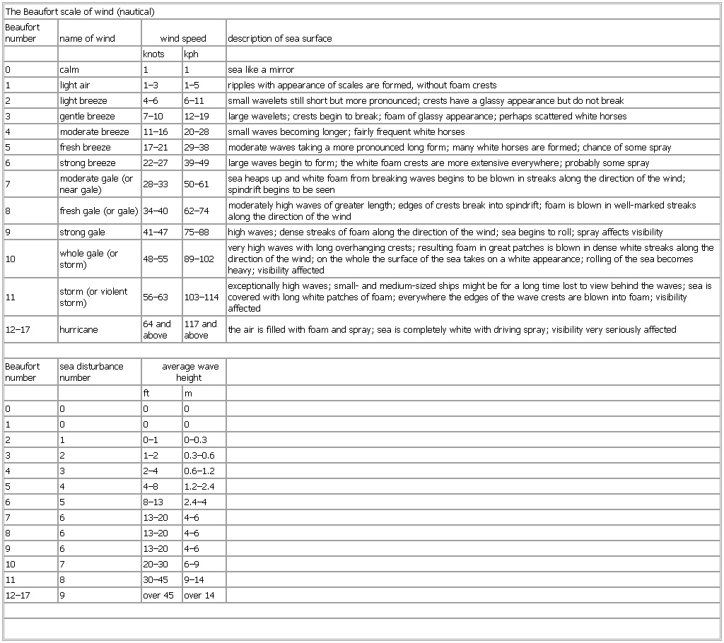
* * *
Universalium.
2010.
Look at other dictionaries:
Beaufort scale — /boh feuhrt/, (no longer in technical use) 1. a scale of wind forces, described by name and range of velocity, and classified as from force 0 to force 12, or, sometimes, to force 17. 2. a scale of the states of sea created by winds of these… … Universalium
Beaufort scale — Force 12 at sea. The Beaufort Scale ( / … Wikipedia
Beaufort wind scale — ranges of wind speeds which are reported as nautical miles per hour in marine weather forecasts while general weather forecasts report wind speeds in kilometres per hour. Beaufort values 13 to 17 have wind speeds in knots at 72 80, 81 89, 90 99,… … Dictionary of ichthyology
Glossary of nautical terms — This is a glossary of nautical terms; some remain current, many date from the 17th 19th century. See also Wiktionary s nautical terms, Category:Nautical terms, and Nautical metaphors in English. Contents: A B C D E F G H I J K L M N O P Q R … Wikipedia
Francis Beaufort — Rear Admiral Sir Francis Beaufort, FRS, FRGS (7 May 1774 ndash; 17 December 1857) was a hydrographer and officer in Britain s Royal Navy. Beaufort was the creator of the Beaufort scale for indicating wind force.BiographyFrancis Beaufort was… … Wikipedia
Icing (nautical) — Icing on ships is a serious hazard where cold temperatures (below about 10°C) combined with high wind speed (typically force 8 or above on the Beaufort scale) result in spray blown off the sea freezing immediately on contact with the ship. If not … Wikipedia
North Sea — For other uses, see North Sea (disambiguation). North Sea Location Atlantic Ocean Coordinates … Wikipedia
Alexander Dalrymple — (July 24, 1737 ndash; June 19, 1808) was a Scottish geographer and the first Hydrographer of the British Admiralty. He was the main proponent of the theory that there existed a vast undiscovered continent in the South Pacific, Terra Australis… … Wikipedia
Knot (unit) — For other uses, see Knot (disambiguation). The knot (pronounced not) is a unit of speed equal to one nautical mile (which is defined as 1.852 km) per hour, approximately 1.151 mph.[1] The abbreviation kn is preferred by the… … Wikipedia
Shipping Forecast — The Shipping Forecast is a four times daily BBC Radio broadcast of weather reports and forecasts for the seas around the coasts of the British Isles. It is produced by the Met Office and broadcast by BBC Radio 4 on behalf of the Maritime and… … Wikipedia