- Danube River
-
River, central Europe.The second-longest European river (after the Volga), it rises in Germany's Black Forest and flows about 1,770 mi (2,850 km) to the Black Sea, passing along or through Germany, Austria, Slovakia, Hungary, Croatia, Yugoslavia, Bulgaria, Romania, and Moldova. Its many tributaries include the Drava, Tisza, and Sava rivers. It has been an important highway between central and eastern Europe from antiquity. The lower Danube is a major avenue for freight transport, and the upper Danube is an important source of hydroelectricity. A regulatory body that consists of its riparian nations was established in 1948 to oversee its use. A major hydroelectric and navigation complex was built in the 1970s at Iron Gate Gorge in Romania. A canal linking Kelheim on it and Bamberg on the Main River, allowing traffic to flow between the North and Black seas, was completed in 1992.
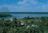 The confluence of the Sava (foreground) and Danube rivers from the Kalemegdan Fortress, Belgrade, ...Jean S. Buldain/Berg & Assoc.
* * *
IntroductionGerman Donau, Slovak Dunaj, Hungarian Duna, Serbo-Croatian and Bulgarian Dunav, Romanian Dunărea, Ukrainian Dunayriver of Europe, the second longest river after the Volga (Volga River). It rises in the Black Forest mountains of western Germany and flows for some 1,770 miles (2,850 km) to its mouth on the Black Sea. Along its course, it passes through nine countries: Germany, Austria, Slovakia, Hungary, Croatia, Serbia, Bulgaria, Romania, and Ukraine.The Danube played a vital role in the settlement and political evolution of central and southeastern Europe. Its banks, lined with castles and fortresses, formed the boundary between great empires, and its waters served as a vital commercial highway between nations. The river's majesty has long been celebrated in music. The famous waltz An der schönen, blauen Donau (1867; The Blue Danube), by Johann Strauss the Younger, became the symbol of imperial Vienna. In the 21st century the river has continued its role as an important trade artery. It has been harnessed for hydroelectric power, particularly along the upper courses, and the cities along its banks—including the national capitals of Vienna (Austria), Budapest (Hungary), and Belgrade (Serbia)—have depended upon it for their economic growth.Physical featuresPhysiographyThe Danube's vast drainage of some 315,000 square miles (817,000 square km) includes a variety of natural conditions that affect the origins and the regimes of its watercourses. They favour the formation of a branching, dense, deepwater river network that includes some 300 tributaries, more than 30 of which are navigable. The river basin expands unevenly along its length. It covers about 18,000 square miles (47,000 square km) at the Inn confluence, 81,000 square miles (210,000 square km) after joining with the Drava, and 228,000 square miles (590,000 square km) below the confluences of its most affluent tributaries, the Sava and the Tisza. In the lower course the basin's rate of growth decreases. More than half of the entire Danube basin is drained by its right-bank tributaries, which collect their waters from the Alps and other mountain areas and contribute up to two-thirds of the total river runoff or outfall.Three sections are discernible in the river's basin. The upper course stretches from its source to the gorge, called the Hungarian Gates, in the Austrian Alps and the Western Carpathian Mountains. The middle course runs from the Hungarian Gates to the Iron Gate Gorge in the Southern Romanian Carpathians. The lower course flows from the Iron Gate to the deltalike estuary at the Black Sea.The upper Danube springs as two small streams—the Breg and Brigach—from the eastern slopes of the Black Forest mountains of Germany, which partially consist of limestone. From Donaueschingen, where the headstreams unite, the Danube flows northeastward in a narrow, rocky bed. To the north rise the wooded slopes of the Swabian and the Franconian mountains; between Ingolstadt and Regensburg the river forms a scenic canyonlike valley. To the south of the river course stretches the large Bavarian Plateau, covered with thick layers of river deposits from the numerous Alpine tributaries. The bank is low and uniform, composed mainly of fields, peat, and marshland.At Regensburg the Danube reaches its northernmost point, from which it veers south and crosses wide, fertile, and level country. Shortly before it reaches Passau on the Austrian border, the river narrows and its bottom abounds with reefs and shoals. The Danube then flows through Austrian territory, where it cuts into the slopes of the Bohemian Forest and forms a narrow valley. In order to improve navigation, dams and protecting dikes have been built near Passau, Linz, and Ardagger. The upper Danube, some 600 miles (965 km) long, has a considerable average inclination of the riverbed (0.93 percent) and a rapid current of two to five miles per hour. Depths vary from 3 to 26 feet (1 to 8 metres). The Danube swells substantially at Passau where the Inn River, its largest upstream tributary, carries more water than the main river. Other major tributaries in the upper Danube course include the Iller, Lech, Isar, Traun, Enns, and Morava rivers.In its middle course the Danube looks more like a flatland river, with low banks and a bed that reaches a width of more than one mile. Only in two sectors—at Visegrád (Hungary) and the Iron Gate—does the river flow through narrow, canyonlike gorges. The basin of the middle Danube exhibits two main features—the flatland of the Little Alfold and the Great Alfold plains, and the low peaks of the Western Carpathians and the Transdanubian Mountains.The Danube enters the Little Alfold plain immediately after emerging from the Hungarian Gates Gorge near Bratislava, Slovakia. There the river stream slows down abruptly and loses its transporting capacity, so that enormous quantities of gravel and sand settle on the bottom. A principal result of this deposition has been the formation of two islands, one on the Slovak side of the river and the other on the Hungarian side, which combined have an area of about 730 square miles (1,900 square km) that support some 190,000 inhabitants in more than 100 settlements. The silting hampers navigation and occasionally divides the river into two or more channels. East of Komárno the Danube enters the Visegrád Gorge, squeezed between the foothills of the Western Carpathian and the Hungarian Transdanubian Mountains. The steep right bank is crowned with fortresses, castles, and cathedrals of the Hungarian Árpád dynasty of the 10th to 15th century.The Danube then flows past Budapest and across the vast Great Alfold plain until it reaches the Iron Gate gorge. The riverbed is shallow and marshy, and low terraces stretch along both banks. River accumulation has built a large number of islands, including Csepel Island near Budapest. In this long stretch the river takes on the waters of its major tributaries—the Drava, the Tisza, and the Sava—which create substantial changes in the river's regime. The average runoff increases from about 83,000 cubic feet (2,400 cubic metres) per second north of Budapest to 200,000 cubic feet (5,600 cubic metres) at the Iron Gate. The river valley looks most imposing there, and the river's depth and current velocity fluctuate widely. The rapids and reefs of the Iron Gate once made the river unnavigable until a lateral navigation channel and a parallel railway allowed rivercraft to be towed upstream against the strong current.Beyond the Iron Gate the lower Danube flows across a wide plain; the river becomes shallower and broader, and its current slows down. To the right, above steep banks, stretches the tableland of the Danubian Plain of Bulgaria. To the left lies the low Romanian Plain, which is separated from the main stream by a strip of lakes and swamps. The tributaries in this section are comparatively small and account for only a modest increase in the total runoff. They include the Olt, the Siret, and the Prut. The river is again obstructed by a number of islands. Just south of Cernavodă, the Danube heads northward until it reaches Galaţi, where it veers abruptly eastward. Near Tulcea, some 50 miles (80 km) from the sea, the river begins to spread out into its delta.The river splits into three channels—the Chilia, which carries 63 percent of the total runoff; the Sulina, which accounts for 16 percent; and the Sfântu Gheorghe (St. George), which carries the remainder. Navigation is possible only by way of the Sulina Channel, which has been straightened and dredged along its 39-mile (63-km) length. Between the channels, a maze of smaller creeks and lakes are separated by oblong strips of land called grinduri. Most grinduri are arable and cultivated, and some are overgrown with tall oak forests. A large quantity of reeds that grow in the shallow-water tracts are used in the manufacture of paper and textile fibres. The Danube delta covers an area of some 1,660 square miles (4,300 square km) and is a comparatively young formation. About 6,500 years ago the delta site was a shallow cove of the Black Sea coast, but it was gradually filled by river-borne silt; the delta continues to grow seaward at the rate of 80 to 100 feet (24 to 30 metres) annually.HydrologyThe different physical features of the river basin affect the amount of water runoff in its three sections. In the upper Danube the runoff corresponds to that of the Alpine tributaries, where the maximum occurs in June when melting of snow and ice in the Alps is the most intensive. Runoff drops to its lowest point during the winter months.In the middle basin the phases last up to four months, with two runoff peaks in June and April. The June peak stems from that of the upper course, reaching its maximum 10 to 15 days later. The April peak is local. It is caused by the addition of waters from the melting snow in the plains and from the early spring rains of the lowland and the low mountains of the area. Rainfall is important; the period of low water begins in October and reflects the dry spells of summer and autumn that are characteristic of the low plains. In the lower basin all Alpine traits disappear completely from the river regime. The runoff maximum occurs in April, and the low point extends to September and October.The river carries considerable quantities of solid particles, nearly all of which consist of quartz grains. The constant shift of deposits in different parts of the riverbed forms shoals. In the stretches between Bratislava and Komárno and in the Sulina Channel, draglines are constantly at work to maintain the depth needed for navigation. The damming of the river has also changed the way in which sediments are transported and deposited. Water impounded by reservoirs generally loses its silt load, and the water flowing out of the dam—which is relatively silt-free—erodes banks farther downstream.The temperature of the river waters depends on the climate of the various parts of the basin. In the upper course, where the summer waters derive from the Alpine snow and glaciers, the water temperature is low. In the middle and lower reaches, summer temperatures vary between 71 ° and 75 °F (22 ° and 24 °C), while winter temperatures near the banks and on the surface drop below freezing. Upstream from Linz the Danube never freezes entirely, because the current is turbulent. The middle and lower courses, however, become icebound during severe winters. Between December and March, periods of ice drift combine with the spring thaw, causing floating ice blocks to accumulate at the river islands, jamming the river's course, and often creating major floods.The natural regime of river runoff changes constantly as a result of the introduction of stream-regulating equipment, including dams and dikes. The mineral content of the river is greater during the winter than the summer. The content of organic matter is relatively low, but pollution increases as the waters flow past industrial areas. The river's chemistry also changes as city sewerage and agricultural runoff find their way into the river.The economyThe Danube is of great economic importance to the nine countries that border it—Ukraine, Romania, Serbia, Croatia, Hungary, Bulgaria, Slovakia, Austria, and Germany—all of which variously use the river for freight transport, the generation of hydroelectricity, industrial and residential water supplies, irrigation, and fishing. The movement of freight is the most important economic use of the Danube, and such cities as Izmail, Ukraine; Galaţi and Brăila, Romania; Ruse, Bulgaria; Belgrade, Serbia ; Budapest, Hungary; Bratislava, Slovakia; Vienna, Austria; and Regensburg, Germany, are among the major ports. Since World War II, navigation has been improved by dredging and by the construction of a series of canals, and river traffic has increased considerably. The most important canals—all elements in a continentwide scheme of connecting waterways—include the Danube–Black Sea Canal, which runs from Cernovadă, Romania, to the Black Sea and provides a more direct and easily navigable link, and the Main–Danube Canal (Main-Danube Canal), completed in 1992 to link the Danube to the Rhine and thus to the North Sea.The Danube has been tapped for power, mainly in its upper course. The process, however, has spread downstream. One of the largest hydroelectric projects—the Djerdap High Dam and the Iron Gate power station—was built jointly by Yugoslavia and Romania. Not only does the project produce hydroelectricity but it also makes navigable what was once one of the most difficult stretches on the river.Industrial use of Danube waters is made at Vienna, Budapest, Belgrade, and Ruse. The main irrigated areas are along the river in Slovakia, Hungary, Serbia, and Bulgaria. The river, however, has nearly become unfit for irrigation as well as for drinking water because of the tremendous increase in pollutants; pollution has also diminished the once-rich fishing grounds, although some of the fish have moved to side lakes and swamps.HistoryDuring the 7th century BC, Greek sailors reached the lower Danube and sailed upstream, conducting a brisk trade. They were familiar with the whole of the river's lower course and named it the Ister. The Danube later served as the northern boundary of the vast Roman Empire and was called the Danuvius. A Roman fleet patrolled its waters, and the strongholds along its shores were the centres of settlements, among them Vindobona (later Vienna), Aquincum (later Budapest), Singidunum (later Belgrade), and Sexantaprista (later Ruse).During the Middle Ages the old fortresses continued to play an important role, and new castles such as Werfenstein, built by Charlemagne in the 9th century, were erected. When the Ottoman Empire spread from southeastern to central Europe in the 15th century, the Turks relied upon the string of fortresses along the Danube for defense. The Habsburg dynasty recognized the navigational potential of the Danube. Maria Theresa, queen of Hungary and Bohemia from 1740 to 1780, founded a department to oversee river navigation, and in 1830 a riverboat made a first trip from Vienna to Budapest, possibly for trading purposes. This trip marked the end of the river's importance as a line of defense and the beginning of its use as a channel of trade.Regulated navigation on the Danube has been the subject of a number of international agreements. In 1616 an Austro-Turkish treaty was signed in Belgrade under which the Austrians were granted the right to navigate the middle and lower Danube. In 1774, under the Treaty of Küçük Kaynarca (Küçük Kaynarca, Treaty of), Russia was allowed to use the lower Danube. The Anglo-Austrian and the Russo-Austrian conventions of 1838 and 1840, respectively, promoted free navigation along the entire river, a principle that was more precisely formulated in the Treaty of Paris (Paris, Treaty of) of 1856, which also set up the first Danubian Commission with the aim of supervising the river as an international waterway. In 1921 and 1923, final approval of the Danube River Statute was granted by Austria, Germany, Yugoslavia, Bulgaria, Romania, Great Britain, Italy, Belgium, Czechoslovakia, Hungary, and Greece. The international Danube Commission was thus established as an authoritative institution with wide powers, including its own flag, the right to levy taxes, and diplomatic immunity for its members. It controlled navigation from the town of Ulm to the Black Sea and kept navigational equipment in good repair.During World War II, free international navigation along the course of the river was interrupted by the hostilities, and a consensus concerning the resumption of navigation was not reached until the Danubian Convention of 1948. The new convention provided for the Danubian countries alone to participate in a reconstituted Danube Commission; of these countries, only West Germany did not join the convention.Patricia Garland PinkaAdditional ReadingJosef Breu, Atlas of the Danubian Countries, 11 issues in 2 vol. (1970–89), is a comprehensive, multilingual source on the Danube region's geography. Much of the literature in English on the Danube itself consists of descriptive works based on travel experiences, such as Patrick Leigh Fermor, Between the Woods and the Water: On Foot to Constantinople from the Hook of Holland: The Middle Danube to the Iron Gates (1986); and Claudio Magris, Danube (1989; originally published in Italian, 1986). Navigation of the river and its influence on the economic development of the region are surveyed in J.P. Chamberlain, The Regime of the International Rivers: Danube and Rhine (1923, reprinted 1968); while Stephen Gorove, Law and Politics of the Danube (1964), discusses the regulations of navigation and the river's international importance. A number of works survey the region's long historical significance, including Emil Lengyel, The Danube (1939); Joseph Wechsberg, The Danube: 2000 Years of History, Myth, and Legend (1979); and Spiridon G. Focas, The Lower Danube River in the Southeastern European Political and Economic Complex from Antiquity to the Conference of Belgrade of 1948, trans. from Romanian (1987).Peter Georgiev Penčev* * *
Universalium. 2010.